While most of the devastating flood impacts were being felt in the Western Cornbelt at mid-month, portions of the Eastern Cornbelt were also dealing with floodwaters.
Some residents in the northern Illinois communities of Roscoe and Freeport were forced to evacuate at midweek due to flooding along the Rock and Pecantonica rivers. Michigan Gov. Gretchen Whitmer also declared a state of emergency for Newaygo County in the western part of the state on March 19 after heavy rain and melting snow caused flooding.
Western Cornbelt:
Historic flooding continued at mid-month in Nebraska, southwestern Iowa, and northwestern Missouri, particularly along the Missouri, Elkhorn, and Platte rivers. News reports confirmed at midweek that hundreds of residents in those area have been displaced and more than 100 miles of levees in all three states had been breached or overtopped.
Iowa Gov. Kim Reynolds on March 19 added another five counties to a state disaster proclamation for areas impacted by flooding, with 41 of Iowa’s 99 counties now under a disaster proclamation. In Nebraska, 74 counties, 83 cities, and four tribal areas were under states of emergency as of March 19, Nebraska Gov. Pete Ricketts said on March 20 that “preliminary and initial” damage losses from the flooding in the state are estimated to be more than $1.3 billion, including $439 million in infrastructure losses, $85 million in private homes and business losses, $400 million in livestock, and $440 million in crop losses. The Nebraska Farm Bureau pegged early livestock loss estimates at up to $500 million, including both lost feed and animals.
One local report talked of some $7 million in losses in Iowa’s Fremont County alone due to flooded bins holding more than a million bushels of corn and a half-million bushels of soybeans. The National Weather Service warned at midweek that potentially historic flooding would soon engulf portions of northern Iowa and South Dakota as well, particularly along portions of the Big Sioux and James rivers.
The flood waters have also caused extensive infrastructure damages in Iowa, Nebraska, and Missouri. The west leg of NuStar Energy LP’s ammonia pipeline system in Nebraska has been offline since March 14 due to flooding, and Missouri officials at midweek reported more than 100 flood-related road closures in the state.
Amtrak said on March 19 that it was temporarily suspending its Missouri River Runner passenger rail service between Kansas City and St. Louis, Mo., due to flooding. BNSF Railway also confirmed that floodwaters had caused “major disruptions to service and operations” in Iowa, Nebraska, Missouri, and South Dakota due to “multiple washouts and high water on BNSF main lines” in the area.
 “While BNSF operating teams are rerouting some trains, we have issued embargoes in response to outages through this impacted area,” the company said. “BNSF crews are conducting ongoing assessments and inspections regarding the condition of our main lines. While service on some subdivisions has already been restored, with speed restrictions in place where necessary, normal train flows in the area are likely not to resume for an extended period. Customers should expect continued delays on shipments scheduled to move through the area.”
California:
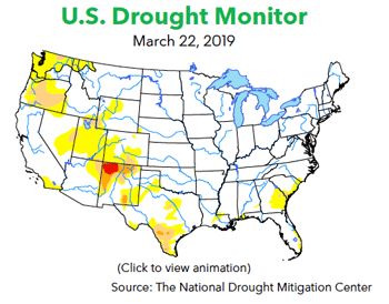
Another powerful atmospheric river brought heavy rain and snow to California in early March, and removed all traces of drought in the state for the first time since 2011. The latest storm brought 1-3 inches of rainfall to parts of southwestern and northern California, along with 1-4 feet of snow in the Sierra Nevada.
According to the National Weather Service (NWS), San Francisco, Sacramento, and Reno recorded double the average precipitation in the period from early February into early March. As of March 14, the average snow water equivalent in the Sierra was at 159 percent of average for the date. For the West as a whole, the NWS noted that just over half of the region was experiencing drought conditions on Jan. 15, but by March 5, barely 25 percent of the region was still in drought.
Sources reported a steady fertilizer application pace in the Central Valley at mid-month, but activity was “still not at full strength,” according to one source.
“Movement has picked up significantly, with the southern half better than the northern half due to higher rainfall amounts in the north,” said another contact. “So far no logistics concerns, but I suspect it is going to come on fast and furious and we will eventually max out what we can do. There is more rain in the forecast, which will mess things up again, I’m sure.”
Pacific Northwest:
Unseasonably warm weather settled over parts of the Pacific Northwest at mid-month, sparking some brisk spring fertilizer activity in parts of Washington and Oregon.
Temperatures soared to 79 degrees in Seattle at midweek, while Quillayute, Wash., posted a record high of 81 degrees on March 19, nearly 30 degrees above normal for that date. Hoquiam, Wash., also set a record high temperature of 79 degrees on March 19-20. Temperatures climbed into the mid- to upper-70s in Oregon’s Willamette Valley during the week as well.
Mid-March weather conditions in western Washington and Oregon marked a significant change from the previous month, when Seattle collected more than 20 inches of snow and Eugene, Ore., picked up 18.8 inches of snow on Feb. 24-27.
Montana enjoyed much warmer weather at mid-month after frigid temperatures in late February and early March. Warm temperatures were also reported in Idaho at midweek, but another cold front was taking aim for the coming weekend, with a wintry mix of precipitation expected in the mountain valleys on March 23.
Western Canada:
Much warmer weather settled over parts of Western Canada in mid-March, prompting flood concerns in some locations. Highs reached a record 24.5 C in Tofino, B.C., at midweek. One Saskatchewan source said the ground was “still covered with snow” in his location at mid-month, but highs were expected to hit 15 C in some locations.
According to the Manitoba Flood Outlook issued on March 18, heavy snow in the northern U.S. and across the Red River Valley is expected to produce major flooding in some areas this spring. If a rapid thaw is accompanied by heavy spring rains, the report said water levels could potentially exceed 2009 levels on the Red River. Officials said the Assiniboine River system is expected to see limited flooding this spring, however.
“It’s starting to melt in southern Alberta,” said one regional source at midweek. “We might see farmers getting their equipment maintained next week, but there will be no fieldwork for a while.” Other regional contacts agreed. “We will likely not see much activity until mid- to late-April in most of our trading area,” said one Western Canada source.
