Eastern Cornbelt:
Dangerous heat continued over much of the Eastern Cornbelt during the week, prompting heat advisories and school closures in some locations. Strong thunderstorms also pushed through parts of northern Ohio at midweek, carrying heavy rain and damaging winds.
Highs in the low to mid-90s were common across central Illinois, with humidex readings in the 105-115 range. Heat index values in northeastern Illinois climbed as high as 117 degrees on Aug. 24, with excessive heat warnings in effect until 8 p.m.
Similar conditions were reported in Indiana, with heat indices climbing on Aug. 24 to 110 degrees in Indianapolis and Bloomington, 111 in South Bend and Lafayette, 113 in Terre Haute, and 114 in Evansville.
The combination of adequate moisture and plentiful heat and humidity continued to benefit crops in the Eastern Cornbelt. Good or excellent ratings were assigned on Aug. 20 to 72-74% of Ohio’s corn and soybeans, compared with 66-68% in Indiana and 64-65% in Illinois.
Western Cornbelt:

Much of Iowa was under excessive heat warnings during the week. Several daily temperature records were set, including 100 in Des Moines on Aug. 23, 101 in Sioux City on Aug. 22, and 98 in Waterloo on Aug. 22.
Triple-digit highs were also reported in multiple Nebraska locations during the week, while much of Missouri saw temperatures reach the upper-90s during the week. High humidity pushed humidex readings to as high as 116 in Kansas City, 114 in Columbia, and 109 in Springfield on Aug. 22.
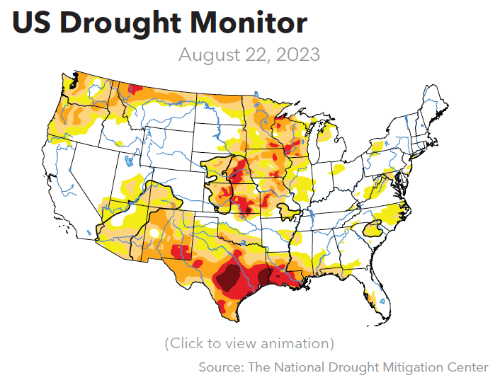
Patches of extreme-to-exceptional drought continued to be reported in eastern Nebraska and western Missouri during the week.
Good or excellent ratings were assigned to 35-44% of Missouri’s corn and soybeans on Aug. 20, compared with 58-61% in Nebraska and Iowa. Good or excellent ratings were also assigned to 74% of Nebraska’s sorghum crop, along with 70% of Missouri’s cotton and 75% of Missouri’s rice crop.
Northern Plains:
Heat advisories were issued for southern Minnesota and portions of South Dakota during the week, with temperatures soaring to the low-90s in Minnesota and the low-100s in South Dakota. Daily records were reportedly set in South Dakota on Aug. 21 at 101 in Pierre and 107 in Winner, with heat indices climbing to as high as 115 degrees on Aug. 23.
Drought conditions ranging from moderate to severe were reported across much of Minnesota and northern North Dakota. Just 45% of Minnesota’s corn was rated as good or excellent on Aug. 20, compared with 56-60% in the Dakotas. Soybeans in the good or excellent categories totaled 59% of the acreage in South Dakota, 53% in Minnesota, and 46% in North Dakota.
USDA reported that 39-46% of the barley was harvested in North Dakota and Minnesota by Aug. 20, while the spring wheat harvest had progressed to 75% complete in South Dakota, 41% in Minnesota, and 24% in North Dakota. Fully 87% of South Dakota’s oat crop was in the bin by Aug. 20, compared with 73% in Minnesota and 27% in North Dakota.
Great Lakes:
Heat advisories were in place across southern Michigan and southern Wisconsin as the week progressed, with forecasts warning of temperatures reaching the low-90s and heat indices climbing to 100-105 degrees.
The high heat and humidity sparked several strong thunderstorms across the region, with most of southeastern Michigan bracing for potentially severe storms carrying 60 mph winds and large hail late on Aug. 24.
Nearly all of Wisconsin was experiencing drought conditions in late August, with areas of severe-to-extreme drought reported in southern and western areas of the state. Drought conditions in Michigan were largely absent by the end of the month, though small areas of moderate drought persisted across northern parts of the state.
Good or excellent ratings were assigned on Aug. 20 to 54-55% of the corn crop in Michigan and Wisconsin, while soybeans in those two categories totaled 56-60% of the regional crop.
Northeast:
Parts of New England were bracing for another wet weekend as the remnants of post-Tropical Storm Hilary make their way into the region.
A Great Lakes system also brought scattered showers to Pennsylvania during the week, with high heat and humidity expected as the week progressed. The combination of heat and moisture benefited corn crops in the state, with fully 86% of Pennsylvania’s corn acreage rated as good or excellent on Aug. 20.
Eastern Canada:
Wet weather continued to take a toll on crop conditions across much of Eastern Canada. The latest system was expected to bring heavy rain to southern Ontario on Aug. 23-24, with nearly two inches predicted in some areas, along with the potential for large hail and damaging winds.
Portions of Quebec and the Maritimes were hit with heavy rain over the previous weekend, with nearly three inches reported in central Quebec and an inch or more in Halifax.