Eastern Cornbelt:
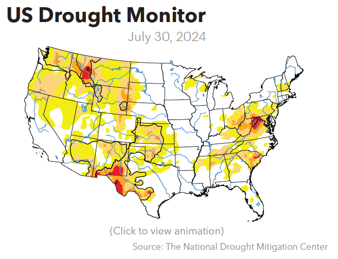
Strong thunderstorms tracked through central and northern Illinois at midweek, with reports of locally damaging winds and quarter-sized hail in some locations.
A severe thunderstorm watch was also in effect for southeastern Illinois and southern Indiana on Aug. 1, with forecasts warning of 70 mph winds, hail up to an inch in diameter, and possible tornadoes. The midweek storm followed an earlier system that produced an EF-2 tornado in Indiana’s Madison County on July 29.
Pop-up storms were also reported in central Ohio as the week progressed, along with high heat and humidity. Heat index readings were approaching the triple digits in parts of eastern Ohio on Aug. 1.
Good or excellent ratings were assigned to 72-76% of the corn and soybeans in Illinois on July 28, compared with 69-70% in Indiana and 63-66% in Ohio.
Western Cornbelt:
Thunderstorms packing gale-force winds, heavy rain, hail, and several tornadoes blew across Nebraska and the southern half of Iowa late on July 31.
The Omaha-Council Bluffs area of Nebraska bore the brunt of damage from the storm, with reports of more than 220,000 residents without power after 90 mph winds slammed the region. The system spawned at least two tornadoes and slowed traffic on I-80 due to multiple overturned 18-wheelers.
The storm weakened as it moved east, but a severe thunderstorm watch remained in effect for at least 14 Iowa counties on Wednesday evening into early Thursday. About 16,600 customers were without power in central Iowa on Wednesday evening, according to MidAmerican Energy.

Severe thunderstorms also churned through the Kansas City, Mo., area at midweek, leaving more than 70,000 residents without power.
Fully 74-78% of the regional corn crop and 75-76% of the soybeans were rated as good or excellent on July 28, along with 80% of Nebraska’s sorghum, 76% of Missouri’s rice, and 60% of Missouri’s cotton crop.
Northern Plains:
Strong storms battered parts of South Dakota and southern Minnesota during the week, with reports of damaging winds and large hail in some locations.
The first system on July 29-30 produced 50-70 mph winds and spotty hail across south-central South Dakota. A second system on July 31 caused flash flooding in Brookings, S.D., and multiple rounds of strong thunderstorms in central and southern Minnesota.
South Dakota’s corn and soybeans were 72% good or excellent as of July 28, compared with 58-60% in Minnesota and 51-65% in North Dakota. The winter wheat harvest was 63% complete in South Dakota by that date, while the spring wheat and barley harvest was just starting in all three states.
Good or excellent ratings were assigned to 77-83% of Minnesota’s spring wheat, barley, and oats, compared with 74-82% in North Dakota and 70-75% in South Dakota in late July.
Northeast:
Much of the Northeast was bracing for another round of heat and humidity as the week progressed, with highs reaching the low- to mid-90s. Heat advisories were in effect for multiple locations during the week, while scattered showers were reported in New York. More widespread rain was expected in New England by the weekend.
Crop conditions continued to be described in very favorable terms in the Northeast, with fully 83% of Pennsylvania’s corn rated as good or excellent on July 28.
Eastern Canada:
Slow-moving thunderstorms dropped heavy rain in southern Quebec at midweek, causing localized flooding and power outages from strong wind gusts. Some locations reported as much as 60 mm of rain per hour on July 31.
Spotty showers also rolled through the Maritimes on Aug. 1, with heat and high humidity driving humidex readings up to the mid-30s C in many locations.
