 Eastern Cornbelt:
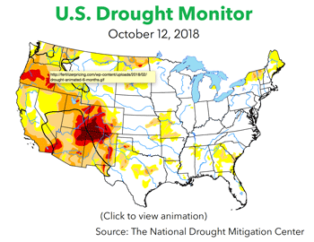
Heavy rain over the prior weekend resulted in flash flood watches for parts of northern Illinois early in the week. One contact said the Quad-City area has received more than four inches of rain since Oct. 1, compounding harvest delays in that area.
In addition to the moisture, much cooler temperatures were also moving into the Eastern Cornbelt. A freeze warning and frost advisory were in effect for northeastern Illinois late in the week, with lows expected to dip to the upper-20s and low-30s. Below-normal temperatures were also expected in Indiana and Ohio for the weekend.
Despite the weather delays, the harvest continued to track ahead of the average pace in Illinois and Indiana, and crop conditions remained excellent.
USDA reported that 63 percent of the Illinois corn crop was in the bin by Oct. 7, along with 39 percent of the crop in Indiana and 21 percent in Ohio. Harvest progress in all three states was ahead of the five-year average, with good or excellent ratings assigned to 80-83 percent of the acreage in Illinois and Ohio, and 72 percent in Indiana.
 The regional soybean harvest was 51 percent complete in Illinois, compared with 40 percent in Indiana and 30 percent in Ohio. As with corn, fully 80-84 percent of the soybeans in Illinois and Ohio were rated as good or excellent in early October, along with 72 percent of the acreage in Indiana.
Western Cornbelt:
Wild weather was reported in parts of the Western Cornbelt for October, with tornadoes in Iowa, snow in Nebraska, and torrential rain in parts of Missouri.
The National Weather Service said nearly a dozen tornadoes touched down in rural areas across Iowa on Oct. 9, with reports of spotty damage to farm structures and crops in southern, central, and eastern Iowa. High winds and heavy rain were reported in western Iowa and eastern Missouri, while parts of north-central Nebraska collected 1-2 inches of snowfall early in the week. A freeze warning was also in effect for Hastings, Neb., at midweek.
Harvesting continued on corn, soybeans, cotton, and sorghum in the region, as weather conditions allowed. Missouri’s corn harvest was already 76 percent complete by Oct. 7, compared with 23 percent in Nebraska and 15 percent in Iowa. The soybean harvest was 36 percent complete in Nebraska by that date, compared with 18-20 percent in Iowa and Missouri.
USDA assigned good or excellent ratings to fully 79-82 percent of Nebraska’s corn and soybeans, compared with 70 percent in Iowa. Crop conditions in Missouri were not quite as good, with good or excellent ratings assigned to 28 percent of the corn, 49 percent of the soybeans, 46 percent of the sorghum, and 61 percent of the cotton. Nebraska’s sorghum crop, by contrast, was 81 percent good or excellent.
Sources continued to report some preplant fertilizer movement on winter wheat, which was 14 percent planted in Missouri and 87 percent in Nebraska.
Southern Plains:
Strong storms rumbled through Texas, Oklahoma, and eastern Kansas early in the week, producing heavy rain, damaging winds, and flooding in some locations, along with much cooler temperatures.
Wichita collected 3.09 inches of rain on Oct. 8, setting a record for that date and prompting concerns about river flooding in that area. Tornado watches were in effect in the Kansas City area on Oct. 9, with reports of 1-3 inches of rain falling in that location. Tornado, thunderstorm, and flood warnings were also in effect for parts of Oklahoma, with reports of straight-line winds flipping cars in the Oklahoma City area on Oct. 9.
Up to 12 inches of rain fell over a three-day period in northern Texas, causing widespread flooding, particularly on the South Llano River. Parts of New Mexico were also in the storm mix during the week, with reports of thunderstorms late in the week from Tropical Storm Sergio.
Kansas growers had 14 percent of the soybeans harvested by Oct. 7, with 59 percent rated as good or excellent. The region’s corn harvest was progressing ahead of normal, with progress estimated at 20 percent complete in Colorado, 59 percent in Kansas, and 72 percent in Texas. USDA assigned good or excellent ratings to 73 percent of Colorado’s corn crop, compared with 47 percent in Kansas and 29 percent in Texas.
The cotton harvest was 28 percent complete in Texas by Oct. 7, compared with just 1-7 percent in Kansas and Oklahoma, with good or excellent ratings assigned to 74 percent of the Kansas crop, 28 percent in Texas, and just 14 percent in Oklahoma.
The region’s sorghum harvest was also underway, with progress estimated at 77 percent complete in Texas, 41 percent in Oklahoma, 16 percent in Kansas, 13 percent in Colorado, and 5 percent in New Mexico. Sorghum in the good or excellent categories totaled 70-71 percent of the acreage in Kansas and Oklahoma, 64 percent in Colorado, 52 percent in New Mexico, and just 23 percent in Texas
South Central:
Spotty thunderstorms and much cooler temperatures were reported in the South Central region during the week.
Tornado warnings were in effect for several counties in central Arkansas on Oct. 9 as strong storms pushed through the state, while temperatures in Tennessee and Kentucky dropped from summer highs in the 80s down to the 30s and 40s as the week progressed.
Louisiana also saw a big temperature drop, with highs in Baton Rouge falling from the upper-80s to the mid-50s. Hurricane Michael also sent some thunderstorms, gusty winds, and minor flooding to the Mississippi and Louisiana coasts as it approached the Florida panhandle.
Sources said crop yields in parts of the region have taken a hit from surplus moisture in recent weeks, particularly for soybeans. “When you put additional discounts on for quality, the final price is not good,” said one contact.
The soybean harvest was 29-32 percent complete in Kentucky, Tennessee, and Arkansas, compared with 61-79 percent in Mississippi and Louisiana. USDA assigned good or excellent ratings to 53 percent of the acreage in Louisiana, 67 percent in Arkansas and Mississippi, and 72-76 percent in Tennessee and Kentucky.
Growers were nearly finished with the region’s rice and corn harvest. The latter was estimated at 71-79 percent complete in Kentucky and Tennessee by Oct. 7, with 79-80 percent of the acreage rated as good or excellent. The cotton harvest was also advancing, with 63-80 percent of the regional crop rated as good or excellent and progress as of Oct. 7 estimated at 33 percent complete in Tennessee, 40 percent in Mississippi, 45 percent in Arkansas, and 51 percent in Louisiana
Southeast:
Sources said the impact of Hurricane Michael on cotton, peanut, and pecan crops in the Southeast could be devastating. The storm, which hit the Florida panhandle on Oct. 10 as a Category 4 storm, brought heavy rain and damaging winds to parts of northern Florida, Georgia, Alabama, the Carolinas, and Virginia.
“The bad news is that it is coming right through some of the most productive farmland in the whole state,” said one Georgia contact at midweek. “I guess I am more concerned with a tornado forming than with the high winds from the hurricane.”
Crop conditions as of Oct. 7 remained largely favorable in areas that were unaffected by Hurricane Florence in September, but crops in North Carolina had clearly taken a hit. North Carolina corn was 88 percent harvested with 33 percent of the acreage rated as good or excellent, while soybeans in the state were 11 percent harvested and 46 percent good or excellent.
The cotton harvest was just 8-10 percent complete in the Carolinas, compared with 12 percent in Georgia, 19 percent in Alabama, and 3 percent in Virginia. USDA assigned good or excellent ratings to fully 77-80 percent of the cotton acreage in Virginia and Alabama, compared with 58-59 percent in South Carolina and Georgia, and just 33 percent in North Carolina.
The peanut harvest was 58 percent complete in Florida by Oct. 7, compared with 38 percent in Georgia, 34 percent in Virginia, 25-28 percent in North Carolina and Alabama, and just 14 percent in South Carolina. Although North Carolina’s peanut crop was just 52 percent good or excellent for the week, conditions elsewhere were much better, with good or excellent ratings assigned to 70-74 percent of the acreage in South Carolina, Georgia, and Alabama, 78 percent in Virginia, and fully 88 percent in Florida.

 The regional soybean harvest was 51 percent complete in Illinois, compared with 40 percent in Indiana and 30 percent in Ohio. As with corn, fully 80-84 percent of the soybeans in Illinois and Ohio were rated as good or excellent in early October, along with 72 percent of the acreage in Indiana.
 Atlantic:
 The Baton Rouge, La., river gauge was noted below the 30-foot flood stage, falling to 27.6 feet and holding on Oct. 10.
 Industrial Lock delays were generally quoted up to six hours for the week, with occasional wait times spiking to 25 hours. The Colorado Floodgates reported multiple 12-25 hour delays, while waits were described as peaking at 7-9 hours at Brazos Lock’s western gate.
 Tow lengths continued to be reduced to nine barges from the usual 15 on southbound transits between St. Paul, Minn., and Prairie du Chien, Wisc., due to elevated river levels. The Corps limited barge counts to 12 from Prairie du Chien to St. Louis, also down from 15. Southbound tows were slashed by five barges between St. Louis and New Orleans.