Eastern Cornbelt:
The week began with cold temperatures across much of the Eastern Cornbelt, along with rain and snow in many areas. Temperatures fell to the 20s in central Illinois on Oct. 18, with highs struggling to reach the 50s.
Lake-effect snow blanketed parts of northern Indiana earlier in the week, with wind chills dropped to the mid-20s and low-30s across the state. A mix of rain and snow was also seen in northern Ohio on Oct. 18, and a freeze watch was in effect for inland counties of northeastern Ohio. Highs in the upper-40s were reported across northern Ohio as the week progressed.
Warmer weather was reported in Illinois as the week advanced, with highs reaching the 60s and 70s by Oct. 20-21. Forecasts warned of potentially heavy rain early next week, however.
The corn harvest had progressed to 47% complete in Illinois by Oct. 16, compared with 39% in Indiana and 24% in Ohio, while the regional soybean harvest was estimated at 51-57% complete by that date. Good or excellent ratings were assigned to 71-73% of the corn and soybeans in Illinois, 61-62% in Ohio, and 58% in Indiana.
Winter wheat planting was also well underway in the region, with progress estimated at 66% complete in Ohio, 47% in Indiana, and 39% in Illinois.
Western Cornbelt:
Record cold temperatures were seen in Iowa on Oct. 18, with lows falling to the mid- to upper-teens in northern areas of the state.
Highs across Nebraska fell to the upper-40s and low-50s early in the week, with lows dropping to the upper-teens and low-20s. Warmer temperatures returned as the week advanced, with highs reaching the 60s in Nebraska and Iowa on Oct. 20.
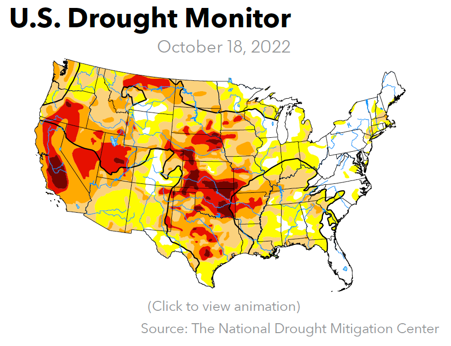
With drought conditions worsening in Nebraska and Missouri, the weekend forecast warned of increased fire danger from gusty winds.
The corn harvest as of Oct. 16 was ahead of the average pace at 67% complete in Missouri, 46% in Nebraska, and 38% in Iowa, with soybeans also tracking ahead of normal at 74-76% complete in Iowa and Nebraska, and 38% in Missouri. USDA placed 62-65% of Iowa’s corn and soybeans in the good or excellent categories at mid-month, compared with 50-51% in Missouri and 39-40% in Nebraska.
Missouri’s rice was 88% harvested by Oct. 16, along with 30% of the state’s cotton crop. Nebraska’s sorghum harvest had progressed to 34% complete by that date.
California:
Hot weather returned to Southern California at midweek after several days of cooler temperatures and scattered showers. Highs reach the mid-90s in some locations on Oct. 19.
Northern California, by contrast, was expecting cooler weather, gusty winds, and some scattered precipitation by the weekend, with snow expected at higher elevations on Oct. 22. Less than a half-inch of rain was likely in the valleys and foothills.
The cotton harvest as of Oct. 16 was 30% complete in California and 33% in Arizona, with good or excellent ratings assigned to 95-99% of the acreage in those two states. California’s rice harvest was 60% complete, and roughly 17% of the state’s winter wheat crop was planted by that date.
Pacific Northwest:
Above-normal temperatures remained in place over much of the Pacific Northwest, but much cooler weather was on tap for the coming weekend, along with some overdue precipitation.
Highs in the 70s were common across Idaho and Montana for most of the week. A cold front was in the weekend forecast, however, with highs in western Montana expected to top out in the mid-30s by Oct. 23. Along with the cold temperatures, rain and snow was expected across a wide swath of both states.
Rain was also in the weekend forecast for parts of Oregon and Washington, with up to an inch of precipitation expected in the Cascades. The moisture will help clear the air of thick smoke caused by both the Nakia Creek Fire and the Bolt Creek Fire in Washington.
Idaho growers had 43% of the sugar beets harvested by Oct. 16, compared with 37% in Montana, while the potato harvest had progressed to 85% complete in Idaho and Oregon and 77% in Washington. Winter wheat planting was estimated at 89% complete in Washington and Montana, 83% in Idaho, and 71% in Oregon.
“Harvest is wrapping up here in the Columbia Basin,” commented one Washington source at midweek. “Fall fertilizer has been very active in the Palouse area, although the dry weather has held back the Willamette Valley from a historically good fall fertilizer market.”
Western Canada:
Mild temperatures were reported across much of Manitoba and Saskatchewan during the week, marking a big change from the snow squalls that hit parts of the region on Oct. 12-13.
Alberta also enjoyed highs in the 20s C for most of the week, but much colder weather was expected by the coming weekend, with highs topping out in the low teens and snowfall hitting some areas. Rain was likely across British Columbia by the weekend, ending a stretch of summer-like heat.
With harvest mostly complete in Alberta, dryland yields were reportedly running about 6% above the 10-year average for the province as a whole. Saskatchewan’s fall harvest was virtually complete by mid-October, while harvest progress in Manitoba was reported at 90% complete, nearly caught up to the five-year average of 91%.
The fall fertilizer season was well underway, sources reported, although dry conditions limited application in some areas.

