Eastern Cornbelt:
Power outages and storm damage were reported across central Illinois on June 29 after powerful storms ripped through the region. Strong winds upended several semis on I-57 during the storm, forcing temporary highway closures.
The powerful system then plowed through central Indiana, causing nearly 50,000 power outages across western areas of the state during the afternoon of June 29. While Ohio was largely spared from storm damage, much of the state remained under air quality advisories due to smoke from Canadian wildfires. Air quality alerts were also posted in Michigan during the week.
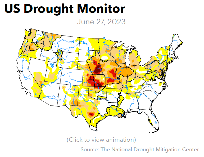
With severe drought now covering most of Illinois, crop conditions in the state worsened in late June. Just 25-26% of the corn and soybeans in Illinois fell in the good or excellent categories as of June 25, compared with 47% in Indiana and 66% in Ohio. Michigan’s crops were also struggling from drought, with 28% of the corn and just 23% of the soybeans rated as good or excellent.
Western Cornbelt:
A band of rain and thunderstorms moved through southeastern Nebraska and southern Iowa late in the week, prompting a severe thunderstorm watch on June 29, with forecasts warning of 50-60 mph winds.
The storm zone also included northern Missouri, where wind gusts up to 80 mph were reported after heat index values climbed to 96-108 degrees across the state. Forecasts warned of another round of potentially severe storms across northern Missouri on June 30.
Severe-to-exceptional drought continued to cover central and eastern Nebraska, central and northern Missouri, and portions of southern, western, and eastern Iowa. Crop quality was deteriorating as a result, with just 31-32% of Missouri’s corn and soybeans rated as good or excellent on June 25, compared with 47-57% in Nebraska and Iowa.
Nebraska’s sorghum crop was 61% good or excellent in late June, while Missouri’s cotton and rice were 64% and 74% good or excellent, respectively.
Southern Plains:
Much of the Southern Plains experienced sweltering heat and strong thunderstorms in late June, with triple-digit heat reported in southern Kansas during the week. Highs in Wichita reached 102-103 degrees at midweek, while severe thunderstorms tracked through southern areas of the state on June 27.
Oklahoma also registered very high temperatures during the week, but damaging storms on June 27 prompted severe thunderstorm watches for several counties, with reports of 100-mph winds in parts of northern Oklahoma.
A heat dome remained in place over much of Texas, pushing temperatures into the triple digits and causing at least 13 deaths in the state since mid-June. According to news reports, the city of Laredo on June 28 had recorded 16 consecutive days of 105+ degree temperatures. Heat advisories were also in effect across southern New Mexico during the week.
A wide swath of extreme-to-exceptional drought continued to blanket central Kansas, but crop conditions remained largely positive. USDA placed 55% of the Kansas corn crop in the good or excellent categories on June 25, compared with 63% in Texas and 76% in Colorado. The Kansas soybean crop was 56% good or excellent, while cotton in those two categories covered 51% of the Kansas crop, 32% in Texas, and fully 76% of the acreage in Oklahoma.
Growers were planting sorghum and harvesting winter wheat in late June, with progress on the former estimated at 66-98% complete across the region. The winter wheat harvest was 74% complete in Texas by June 25, compared with 55% in Oklahoma and 21% in Kansas.
South Central:
Excessive heat warnings and advisories were in effect for southern Kentucky, Middle Tennessee, Arkansas, and southern Louisiana and Mississippi during the week, with heat indices expected to reach 100-115 degrees across the region.
An air quality alert was also in effect for parts of the region due to smoke drifting in from Canadian wildfires. The forecasts called for spotty thunderstorms during the week as well, with a chance of severe storms in parts of Arkansas and Tennessee, including the potential for tornadoes, damaging winds, hail, and heavy rain.
Crop conditions were favorable in the region in late June, with good or excellent ratings assigned to 66-72% of the regional soybean crop and 60-73% of the corn in Kentucky and Tennessee. Cotton in the good or excellent categories totaled fully 84% of Louisiana’s crop, 77% in Arkansas, 75% in Tennessee, and 64% in Mississippi, while rice in those two categories covered 73% of the crop in Texas, 67% in Arkansas, 60% in Mississippi, and 57% in Louisiana.
Southeast:
Severe storms on June 26 produced strong wind, lightning, hail, and heavy rain across central North Carolina, causing flooding in some locations and leaving up to 35,000 residents without power in Benson, Fayetteville, and northern Raleigh.
The same system also caused widespread power outages in central Virginia, while another band of powerful thunderstorms battered parts of central and northern Georgia late on June 25, leaving up to 300,000 residents without power.
Alabama experienced near-record temperatures in the 100s and a heat index close to 110 degrees during the week, with much of Florida also baking in excessive heat.
Crop conditions remained largely favorable in the region, with 72-74% of North Carolina’s corn and soybeans rated as good or excellent as of June 25.
Cotton rated as good or excellent totaled 99% of Virginia’s acreage, compared with 75% in Alabama, 60% in Georgia, and 57-59% in the Carolinas. Fully 100% of Virginia’s peanut crop was in the good or excellent categories, along with 84% of the acreage in Alabama, 78-79% in the Carolinas, 75% in Florida, and 63% in Georgia.
“Crops look good, but the fields are extremely wet from all the rain we’ve been getting,” said one Georgia contact. “Our biggest concern right now is getting fertilizer out; they have barely applied right now because of the rain. We are having a really hot spell, though, so fields should be drying up quick.”

