Eastern Cornbelt:
Summer temperatures in the upper-80s were reported in northern Illinois during the week, while southern areas of the state were expecting potentially heavy rain from the remnants of Hurricane Francine late in the week. The heaviest rain was predicted on Sept. 13-15 for locations south of I-70.
Rain from Francine was also expected in southern Indiana and parts of southern Ohio, though forecasts said the precipitation will not be “heavy or prolonged” in either state. Conditions remained dry in northern Indiana and Ohio, with highs falling from the mid-80s to the 70s as the week progressed.
Growers in Illinois and Indiana had 1-2% of the corn in the bin by Sept 8, with good or excellent ratings assigned to 70-75% of the corn and soybeans in Illinois, 68% in Indiana, 59% in Michigan, and 47-49% in Ohio.
Western Cornbelt:
Hot weather and dry conditions were reported across Iowa and Nebraska during the week, with highs reaching the upper-80s and low-90s in many locations.
Similar conditions were reported in western Missouri, while eastern areas of the state were expecting potentially heavy rain late in the week from the remnants of Francine. Forecasts warned of up to 1.5 inches of rain in areas east of Springfield, while areas to the west will likely remain dry.
Good or excellent ratings were assigned on Sept. 8 to 73% of the corn and soybeans in Iowa and Missouri and 65-67% in Nebraska, with 13% of the Missouri corn crop in the bin by that date, compared with just 1% in Nebraska. Missouri’s cotton and rice were 63% and 69% good or excellent, respectively, with 28% of the rice crop harvested by Sept. 8.
Northern Plains:
Warm, hazy conditions continued across the Northern Plains during the week, with highs reaching the mid- to upper-80s in parts of South Dakota and southern Minnesota. The late summer heat is expected to continue into mid-month, though weekend forecasts warned of possible rains in the region.
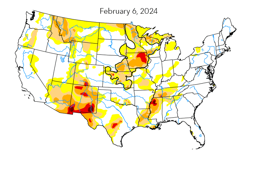
Moderate to severe drought was expanding across western areas of the Dakotas, with abnormally dry conditions reported across much of northern Minnesota and along the southern edge of the state.
USDA on Sept. 8 rated 67-70% of South Dakota’s corn and soybeans as good or excellent, compared with 62-67% in North Dakota and 58-62% in Minnesota. South Dakota’s sorghum was 74% good or excellent with 5% of the crop rated as mature. The harvest of oats, spring wheat, and barley had progressed by Sept. 8 to 97-100% complete in South Dakota, 89-94% in Minnesota, and 79-89% in North Dakota.
Northeast:
Dry, warm weather was reported across New England during the week, with highs reaching the 80s as the week progressed. Similar conditions were noted in Pennsylvania and New York during the week. Though little impact was expected from Francine in the region, some areas were anticipating moderate rainfall by the weekend.
With 4% of Pennsylvania’s corn rated as mature as of Sept. 8, USDA placed 68% of the crop in the good or excellent categories on that date.
Eastern Canada:
Strong storms brought heavy precipitation and gusty winds to the Maritimes on Sept. 7, with reports of 86 mm of rain falling in Halifax and 110 mm in Bridgewater, Nova Scotia. The system also produced 71 km/h winds that knocked out power to some locations.
Nova Scotia was hit with heavy rain again on Sept. 10, but dry, warmer weather was on tap for the balance of the week. Warmer temperatures were also reported across Quebec and Ontario as the week progressed, with highs climbing to the upper-20s C and humidex readings reaching the low-30s C.